[Courtesy of Naver]
SEOUL -- Naver, South Korea's largest web portal, will apply its new navigation service that works with smartphone cameras without GPS to provide indoor directions for travelers roaming through an international airport west of Seoul.
Incheon International Airport, South Korea's main gateway, signed a deal with Naver to introduce a new location and mobility-based platform called "xDM" in the second half of 2019. If passengers enter flight information on Naver's smartphone maps, indoor route information will be provided to guide them to the aircraft gate.
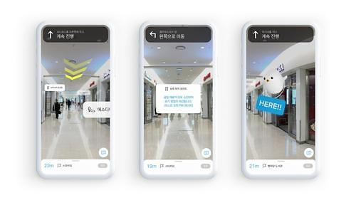
Incheon Airport's official guide app will adopt Naver's augmented reality (AR) navigation service. When travelers set the desired destination, they will be guided with a virtual arrow on the actual image displayed by their smartphone cameras.
Currently, Google provides indoor navigation service through its Google Maps app but the service relies on wifi signals and beacons installed inside buildings because GPS signals often do not work indoors.
"It is possible to provide accurate indoor guidance service to visitors without having to install separate facilities," Naver's chief technology officer Song Chang-hyun said at a technology conference in Seoul, adding users can experience accurate indoor guidance service using AR navigation
Song said the company plans to cooperate with various operators in the future to make xDM South Korea's largest location and mobility-based technology platform.
"Maps are the platform on which the core technology of location and mobility is based," Song said. "We will cooperate with various operators in the future to become the nation's largest mobile platform that can be used more effectively in real life."
Naver will develop high-quality maps for autonomous vehicles, he said, showcasing AROUND G, a platform which can be applied to autonomous guide robots, and a hybrid HD map that allows autonomous vehicles to more precisely track their position. In crowded urban areas, high-rise buildings disrupt GPS signals.